

History of the Nikolaiviertel
Berlin and Cölln – the founding place
 The first written mention of Berlin dates back to 1237. Emerged as merchant and commercial settlements, Berlin and Cölln were named as towns in 1251 and 1261, and were under the rule of the Margraves of Brandenburg. (1) On March 20, 1307, the two towns were united to form the twin city of Berlin-Cölln. A foundation document has not survived or has not yet been found. It was presumably lost in the devastating town fire of 1380. Nevertheless, excavations have shown that people were living at the Spree crossing of the trade routes even before the first written evidence of the town’s existence (towards the end of the 12th century). The construction of a dam to cross the river, through which the river’s water power was used by mills, gave its name to the first named street, the Mühlendamm. The size of this settlement is estimated at around 200 inhabitants. (2),(3) In addition to the excavation finds, there is further evidence that the town was already planned as a complete development when it was founded and was laid out in stages accordingly. In the 13th century, a new town hall with a courthouse was built in the geometric center of the complex. The Molkenmarkt also already existed within the complex at this time. (4)
The city’s first Romanesque basilica was built on the site of today’s Nikolaikirche (Nikolai-Church) in the mid 13th century. The fieldstone masonry in the base of the tower, which is still preserved today, is the oldest surviving part of a building in Berlin. As early as 1264, growing economic power and relative prosperity allowed the citizens to significantly rebuild their central building. The Nikolaikirche became a Gothic hall church, whose most important feature until the second half of the 19th century was the asymmetrical medieval facade with a slender tower. It was not until the 1870s that the neo-gothic twin tower was erected by the Berlin architect Hermann Blankenstein. From the middle of the 15th century, the Hohenzollerns became the new sovereigns and chose the two cities of Berlin and Cölln, which had already formed a formal union in 1307 and shared fortifications, as their residence. Under Elector Frederick II, construction began on the electoral palace “Zwing Cölln”, which became the permanent residence of the Brandenburg electors from 1486 and symbolized the transformation of the medieval trading town into a residential city. (5)
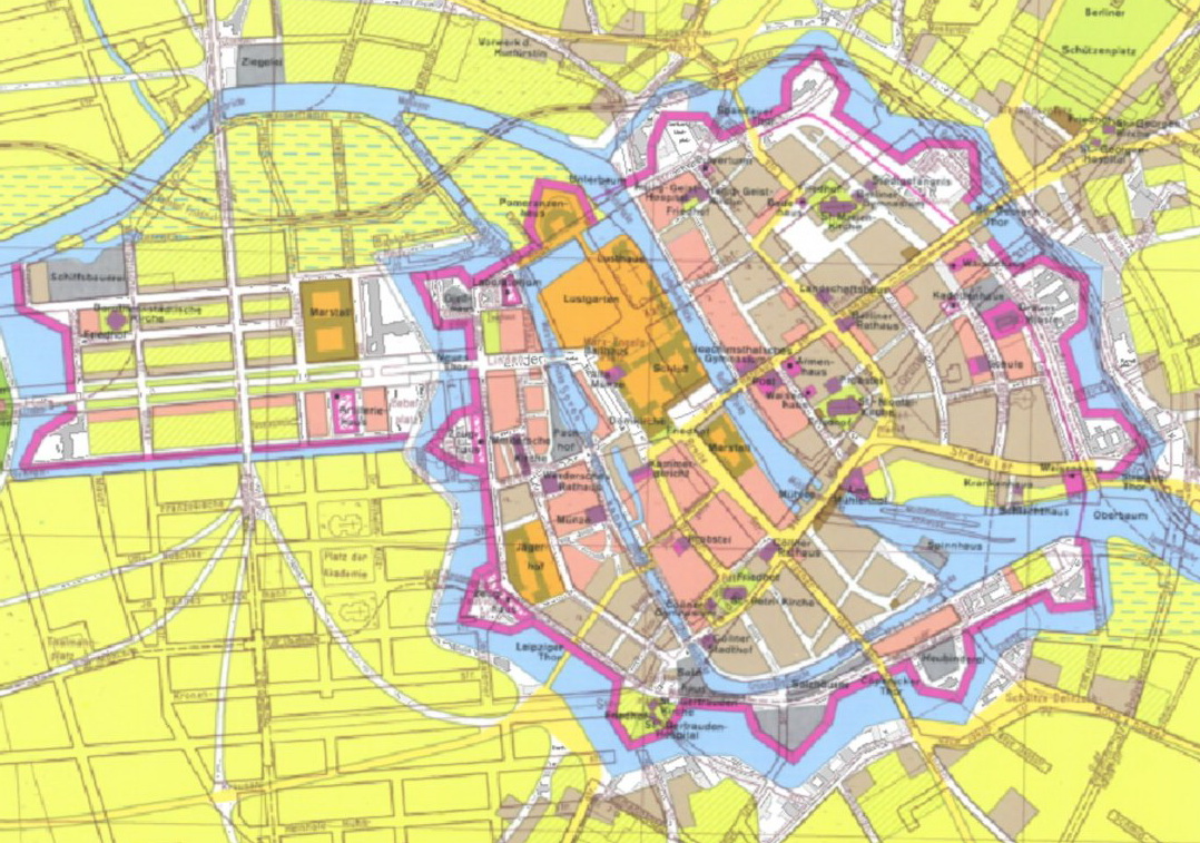
The Thirty Years War had devastating consequences for Berlin and Cölln. The suburbs that had been built up until then were destroyed, and the population was decimated. During this time, Elector Frederick William took over the government in 1640 with the ambitious goal of developing Berlin into a city that could compete internationally with other residential cities. Shortly afterward, Berlin was declared a garrison city and towards the end of the 17th century, a star-shaped fortification belt surrounded by a moat was built around Berlin and Cölln – in line with the now influential military. (6) At the same time, the construction of the Friedrich Wilhelm canal to connect the Oder and Spree rivers turned the city into a hub of what was then the longest continuous waterway in Germany and strengthened its importance as a port city. The economic boom led to considerable immigration and two new districts. Friedrichswerder and Dorotheenstadt were built within the extended fortifications. (7)
Despite shared fortifications and geographical unity, at the beginning of the 18th century Berlin still consisted of the five independent communities of Berlin, Cölln, Friedrichswerder, Dorotheenstadt and Friedrichstadt. It was not until the elevation to the rank of royal residence after the coronation of Frederick I that the newly crowned king ordered the unification of the five into the “Royal Capital and Residence City of Berlin” in 1709 and gave it its own administration. (8),(9) Berlin then developed into a European economic and cultural metropolis in the 18th and 19th centuries. (10)
Even though the structure of the Nikolaiviertel was largely preserved until its destruction in the Second World War, many of the buildings have changed over time. The archaeological excavations carried out by the Berlin State Monuments Office on Mühlendamm in 2019 yielded mostly Wilhelminian-style finds. As in the other historic districts of Old Berlin and Old Cölln, numerous buildings in the Nikolaiviertel have been repeatedly replaced by more modern buildings over the centuries.
Königstraße (today’s Rathausstraße), the link between the Castle and Alexanderplatz, was the main street in Old-Berlin. Spandauer Straße, the link between Molkenmarkt and Spandauer Tor, was also a prestigious and elegant street in Berlin’s old town. Since the beginning of the 20th century, in connection with the industrialization, the rapid growth of the city and the development of car traffic, there have been several considerations about the extension of the streets of the old town of Berlin. This led to numerous demolitions in the 1930s. Among other things, the Mühlendamm was widened to 37 meters, the Ephraim-Palais and the buildings on the Mühlendamm bridge were demolished for reasons of national-socialist ideology.
During the Second World War, between 1943 and 1945, all but five of the plots in the Nikolaiviertel were destroyed. The situation in the Nikolaiviertel remained unchanged until the 1980s. The war-damaged buildings had been demolished, and the Nikolaikirche stood in ruins in the vacated quarter.
Reconstruction and competition of 1978
The planning of a new development on the site of the historic founding place of the city of Berlin, after the almost complete destruction of the Second World War, began around 1960. Plans for the development of a new city center were drawn up as early as the founding of the GDR. The urban history and the founding place as an architectural and cultural-historical anchor point were initially neglected. Priority was given to the construction of a representative headquarters for the government. Later, a plan was to be developed to integrate the river Spree into this new center with a development along the riverbank. As part of these plans, at least the preservation and integration of the Nikolaikirche and the Knoblauchhaus were planned. In 1957/58, a competition was held to redesign the center around the Marx-Engels-Forum, but none of the entries were realized. It was not until a competition for the development of Alexanderplatz in 1964 that planning and finally reconstruction measures began in the historic center of Berlin. This was followed in 1973 by the construction of the Palace of the Republic on the site of the former City Palace. (11)
It was only after the completion of these large-scale redevelopment efforts that the rest of the historic city center was once again the focus of planning efforts. In particular, residential buildings were to be constructed in the city center, in the most heavily frequented areas, in combination with retail shops, restaurants and services. At this time, the Nikolaiviertel was managed within the Rathausstraße-location. (12) In the 1970s, there was finally a reorientation in dealing with these inner-city areas, which aimed to revitalize historic spaces while incorporating the design possibilities of industrial housing construction. (13) Berlin’s founding place around the Nikolaikirche came back into focus. The area was to be redesigned with a reference to the significance of the historic city center. However, the aim was not a 1:1 reconstruction of the medieval buildings, nor a radical structural restructuring of the area. Contemporary architecture should refer to the existing historical substance and structures that once characterized Berlin’s city center. An urban center area with residential buildings was to be created. The plan was to construct around 780 apartments of various sizes, some of which were handicapped accessible, commercial spaces, restaurants and cultural facilities. Buildings, streets and squares with different uses were to form an ensemble so that the reference to the historical buildings and the significance of the location could be experienced structurally, spatially and through works of art in the public space. (14)
The inclusion of historical buildings in the new plans for the Nikolaiviertel can be traced back to an urban planning study from 1974, in which the Knoblauchhaus was to be renovated and given a new use. A plea was then made for the reconstruction of the building structure typical of the 17th and 18th centuries – a novelty in the urban development of the GDR. The approach was widely supported. In 1978, a competition was announced for the redesign with both historical references and links to the urban planning and architectural design of that time. (15) The contract for the planning was awarded to the design team led by Günther Stahn after the competition was completed in 1980. The district and its buildings were built or restored in various construction phases over the following years, divided according to the type of development. In 1987, the redevelopment of the Nikolaiviertel was completed in time for the “750 Years of Berlin” celebrations. The result were around 800 apartments, of which 740 were new builds and 60 were reconstructions of historic buildings The ground floors provided space for 22 restaurants and 33 stores as well as cultural facilities. The Nikolaiviertel is exemplary for the vision of the late GDR urban development: To reclaim historical places in the city center and at the same time to use them as attractive residential areas. The urban development significance lies in its unity as an ensemble and the interpretation of the city’s history that it represents, with extraordinary unique features. (16)
Footnotes:
(1) VON PLESSEN 1987, S. 57
(2) STAHN 1985, S. 12f
(3) WERKSTADT 2016, S. 5
(4) STAHN 1985, S. 15
(5) VON PLESSEN 1987, S. 58
(6) KOSCHNICK 1987, S. 83
(7) KOSCHNICK 1987, S. 84
(8) SCHWENK 2002, S. 103
(9) KOSCHNICK 1987, S. 84.
(10) STAHN 1985, S. 8
(11) WERKSTADT 2016, S. 7f
(12) WERKSTADT 2016, S. 9
(13) Senatsbeschluss 2019, S. 7
(14) STAHN 1985, S. 8f
(15) WERKSTADT 2016, S. 10
(16) WERKSTADT 2016. S. 13f, S. 24
Source historical map: Geoportal Berlin/ Berlin um 1690